Game of Thrones Map – Full Westeros and Essos Interactive Guide
The fictional geography of Westeros and Essos spans thousands of miles of detailed terrain, from the frozen wastelands beyond the Wall to the exotic eastern shores of the Known World. George R.R. Martin’s created universe, central to both the A Song of Ice and Fire novels and HBO’s Game of Thrones, relies on intricate cartography that shapes political alliances, military campaigns, and character journeys.
Official maps derived from Martin’s hand-drawn originals provide the definitive visual framework for this world, while digital tools now offer interactive exploration with spoiler filtering and house-specific overlays. Understanding this geography requires navigating both canonical print materials and fan-developed digital resources that interpret the same source material through different lenses.
This guide examines the complete cartographic landscape, covering interactive digital platforms, official print publications, and the real-world scale comparisons that help contextualize the vast distances traveled by series protagonists.
What Does the Game of Thrones Map Look Like?
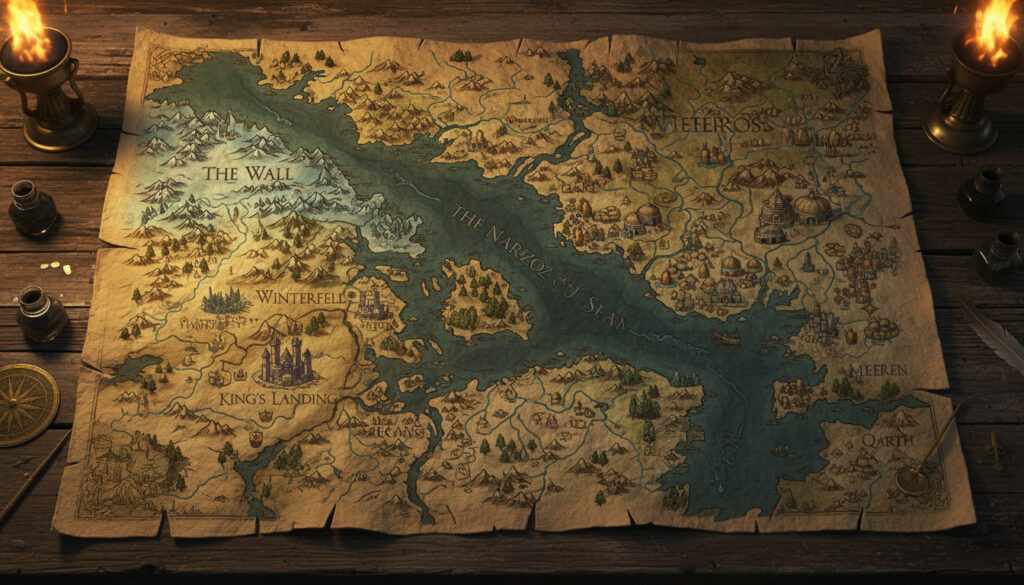
Westeros Overview
The continent stretches approximately 3,000 miles from the Wall to the southern deserts of Dorne, featuring the Seven Kingdoms and the Crownlands.
Essos Highlights
Eastern continent spanning roughly ten times the width of Britain, housing the Free Cities, Dothraki Sea, and distant Asshai by the Shadow.
Seven Kingdoms
Nine distinct administrative regions including The North, Riverlands, Vale, Iron Islands, Westerlands, Crownlands, Reach, Stormlands, and Dorne.
Beyond the Wall
Vast northern territory comprising haunted forests and frozen wastes extending to the Lands of Always Winter.
- Westeros spans roughly 3,000 miles north-to-south, comparable to the vertical length of South America.
- The Seven Kingdoms represent distinct geopolitical regions each historically ruled by specific Great Houses.
- Essos extends considerably wider than Westeros, with the Free Cities clustered along its western coast.
- Official cartography derives directly from George R.R. Martin’s hand-drawn manuscripts.
- Interactive platforms now offer kilometer-to-mile conversions and spoiler-controlled viewing modes.
- The Wall marks the northern boundary of the Seven Kingdoms at the edge of The Gift.
- Canon maps include locations east of Qarth rarely depicted in the television adaptation.
| Region | Ruling House | Key Location | Notable Feature |
|---|---|---|---|
| The North | House Stark | Winterfell | Spans largest area, northernmost inhabited realm |
| Riverlands | House Tully | Riverrun | Network of rivers and fertile plains |
| The Vale | House Arryn | Eyrie | Mountainous stronghold, impregnable fortress |
| Iron Islands | House Greyjoy | Pyke | Cluster of rocky islands in western waters |
| Westerlands | House Lannister | Casterly Rock | Rich gold mines and coastal cliffs |
| Crownlands | House Baratheon | King’s Landing | Capital city at mouth of Blackwater Rush |
| The Reach | House Tyrell | Highgarden | Agricultural heartland, most populous region |
| Stormlands | House Baratheon | Storm’s End | Constantly battered by storms from narrow sea |
| Dorne | House Martell | Sunspear | Desert climate, southernmost kingdom |
| North of Wall | Night’s Watch | Castle Black | Haunted forests and frozen wilderness |
Where Can I Find an Interactive Game of Thrones Map?
Several digital platforms offer navigable versions of Martin’s world, ranging from comprehensive wiki-based tools to customizable visualization software. These resources vary in their treatment of spoilers, interactivity levels, and adherence to book versus show continuity.
Quartermaester and Comprehensive Navigation Tools
Quartermaester.info provides one of the most detailed interactive experiences, covering both Westeros and Essos with toggleable layers for TV episodes and novel spoilers. Users can generate shareable URLs by Ctrl+clicking specific locations, directing others directly to Winterfell or King’s Landing. The platform delineates regions by ruling houses, displaying House Stark’s dominance over The North and House Lannister’s control of the Westerlands.
Wiki-Based and Community Resources
The Wiki of Westeros maintains a gallery of custom interactive maps visualizing locations, items, and world elements from both textual and screen sources. Similarly, the ASOIAF Westeros.org Forum offers clickable regional maps where selecting areas reveals house sigils and territorial details, such as Starks at Winterfell or the Night’s Watch presence at the Wall.
LoreMaps provides metric toggles allowing users to switch between miles and kilometers when measuring distances across Westeros and Essos, essential for understanding the true scale of character journeys.
Customizable and Printable Solutions
For users requiring static outputs, MapChart.net offers editable vector maps where regions can be colored by house affiliation and downloaded as high-resolution images suitable for printing. The interface supports WASD keyboard navigation and zoom functions, allowing precise selection of specific kingdoms before export.
What Are the Key Locations and Seven Kingdoms on the Map?
The political geography of Westeros centers on nine distinct administrative regions collectively known as the Seven Kingdoms, a historical term referencing the pre-Targaryen era when seven sovereign states existed independently.
The Northern Territories and Winterfell
The North constitutes the largest kingdom by land area, stretching from the Neck to the Wall. Winterfell serves as the administrative and cultural center for House Stark, positioned centrally within the region to facilitate governance across vast distances. The Wall marks the absolute northern boundary of the Seven Kingdoms proper, separating the realm from the wildling territories and haunted forests beyond.
The Southern Kingdoms and Crownlands
South of the Neck, the Riverlands, Vale, Iron Islands, Westerlands, Crownlands, Reach, Stormlands, and Dorne each maintain distinct geographical characteristics. King’s Landing, located in the Crownlands where the Blackwater Rush meets the sea, functions as the unified capital despite not being part of the original seven independent kingdoms.
Essos and the Free Cities
Across the Narrow Sea, Essos hosts the Free Cities—Braavos, Pentos, Myr, Lys, and others—clustered along the western coastline. Further east lie the Dothraki Sea, Slaver’s Bay with Meereen, Yunkai, and Astapor, and ultimately the mysterious Shadow Lands and Asshai. These eastern regions appear in detail only in the canonical book maps published in The Lands of Ice and Fire, with some locations omitted from the television adaptation.
Official maps published in 2012 extend canon cartography significantly eastward, revealing locations such as Carcosa and Leng that remain uncharted in HBO’s visual materials.
How Big Is Westeros and How Does It Compare to the Real World?
Understanding the physical scale of Martin’s world requires comparing its dimensions to familiar continental landmasses, though exact measurements remain subject to interpretation based on narrative travel times versus stated distances.
Continental Scale and Measurements
LoreMaps and other metric-enabled platforms indicate Westeros spans approximately 3,000 miles from the Wall to the southern coast of Dorne. This vertical dimension roughly equals the north-south length of South America, or approximately four to five times the length of Britain. Essos extends considerably wider, spanning more than ten times Britain’s width from the Narrow Sea to the distant east.
Book Versus Show Distances
The television adaptation compresses travel distances for narrative pacing, allowing characters to traverse the North in episodes whereas book timelines suggest journeys requiring weeks or months. The official Lands of Ice and Fire collection preserves Martin’s original scale, emphasizing the vast wilderness beyond the Wall that the show visually simplified.
While measurements derived from interactive tools provide useful reference points, Martin has stated that exact distances remain intentionally fluid to serve narrative requirements rather than rigid geographic consistency. The official Lands of Ice and Fire collection preserves Martin’s original scale, emphasizing the vast wilderness beyond the Wall that the show visually simplified, and you can explore this further by checking out the interactive Game of Thrones map at Vem var Blackfisken Masked Singer.
Evolution of the Game of Thrones Map Timeline
The visualization of Martin’s world has undergone significant transformation from initial publication to current digital platforms, with each iteration revealing additional geographic details.
- : A Game of Thrones publishes with initial maps of Westeros, establishing the basic geography of the Seven Kingdoms.
- : HBO launches the television series with adapted cartography that simplifies certain distances for production logistics.
- : Random House publishes The Lands of Ice and Fire, a collection of twelve 3×2 foot poster maps drawn from Martin’s original manuscripts, establishing definitive canon cartography including eastern Essos details.
- : Omniatlas documents faction control shifts across eight seasons, tracking territorial changes as different houses gain or lose kingdoms.
- : Fan-developed interactive platforms launch, offering spoiler-filtered navigation and real-time distance calculation tools.
What Do We Know About Map Accuracy and Canon Sources?
| Established Information | Unclear or Adapted Elements |
|---|---|
| Official maps derive from Martin’s 2012 hand-drawn originals published in The Lands of Ice and Fire. | Exact distances between minor settlements remain unspecified, calculated only through narrative travel time estimates. |
| Westeros measures approximately 3,000 miles north-to-south based on canonical references. | The precise width of Essos at its widest point remains subject to interpretation between different map projections. |
| Book maps include locations east of Qarth (Asshai, Carcosa, Leng) as definitive canon. | HBO’s adaptation omits several eastern locations, compressing Essos for visual storytelling efficiency. |
| The Seven Kingdoms’ political boundaries and ruling houses are consistently documented. | Minor house territories within larger kingdoms sometimes shift between early and later publications. |
| Quartermaester and similar tools allow book/show toggle, distinguishing between source materials. | Fan-generated maps sometimes invent geographic features not present in approved materials. |
Geographic Analysis and Real-World Parallels
The cartography of Westeros deliberately echoes the British Isles, distorted and magnified to continental scale. The North resembles an enlarged Scotland, while the southern kingdoms suggest an extended England and Wales. This geographic inspiration extends to climate patterns, with Dorne representing a Mediterranean or North African equivalent positioned at the southernmost tip.
However, the scale transforms these familiar shapes into something alien—Westeros stretches roughly the length of South America, making the Neck equivalent to the entire length of Britain. This expansion serves narrative isolation, ensuring that Winterfell remains months away from King’s Landing by traditional travel methods. For researchers interested in detailed record-keeping of such comparative analyses, Open Source Note Taking Apps – Best Verified Privacy Options provide secure methods for cataloging geographic research without proprietary platform dependencies.
Essos draws from broader Eurasian influences, with the Free Cities suggesting Italian city-states or ancient Phoenician trading posts, while the Dothraki Sea evokes the steppes of Central Asia. The easternmost regions—Qarth, Asshai, and the Shadow Lands—incorporate Silk Road terminus mythology and distant Asian architectural influences, though Martin maintains these represent fantasy constructs rather than direct historical analogues.
Official Sources and GRRM Quotes
The definitive cartographic sources remain the twelve poster maps published in The Lands of Ice and Fire (Random House, 2012), created directly from Martin’s original drawings. Jonathan Roberts, the cartographer who collaborated with Martin on these official maps, has noted the meticulous process of translating handwritten sketches into precise geographic representations while maintaining the author’s intentional distortions and narrative spatial relationships.
The maps in the books are drawn by me, but they are based on George’s original sketches… He has a very clear sense of where things are in relation to each other, even if the distances sometimes flex to serve the story.
— Jonathan Roberts, Official Cartographer, The Lands of Ice and Fire
I do have maps for Westeros and Essos, and the world beyond… but I prefer to keep some mystery. The maps show what is known to the characters, not necessarily all that exists.
— George R.R. Martin, via Fantastic Maps
Summary and Key Takeaways
The Game of Thrones map encompasses a vast fictional geography spanning Westeros and Essos, defined by official cartography from The Lands of Ice and Fire and interpreted through numerous interactive digital platforms. While Westeros stretches approximately 3,000 miles and mirrors a magnified British Isles, Essos extends eastward to include the Free Cities and distant Asshai, with significant differences between book canon and HBO’s adaptation regarding eastern territories. Platforms like Quartermaester and MapChart provide navigable, spoiler-filtered exploration of these regions, though users should distinguish between official Martin-approved sources and fan expansions. Those tracking historical patterns or territorial control shifts across seasons might find analytical value in Express Entry Draw History – Complete CRS Scores and Results 2015-2024, which demonstrates systematic documentation methods applicable to analyzing complex territorial data over time.
Where exactly is the Wall located on the map?
The Wall stands at the northern boundary of the Seven Kingdoms, marking the edge of The Gift territory. It stretches across the continent’s width, separating the realm from the haunted forests and frozen wastes beyond.
How do spoiler controls work on interactive maps?
Quartermaester.info offers toggleable layers that filter content by specific TV episodes or book chapters, preventing accidental exposure to locations revealed later in the narrative.
What are the Summer Isles and where are they located?
The Summer Isles appear on official poster maps south of Westeros, featuring tropical archipelagos distinct from the continental mainland, though they receive limited narrative focus in the primary series.
How do travel times differ between the books and HBO series?
The show compresses journeys significantly; what requires weeks or months of travel in the books often occurs between episodes in the adaptation, altering the perceived scale of the world.
Where can I purchase official printed poster maps?
FantasticMaps.com offers high-resolution prints of the twelve official maps from The Lands of Ice and Fire, including detailed views of King’s Landing and the Journeys map tracking character routes.
Are there detailed maps of King’s Landing available?
Official poster sets include a dedicated King’s Landing map depicting districts from Flea Bottom to the Red Keep, available through licensed retailers and the publisher’s authorized outlets.
What lies east of Essos on the canon maps?
Official maps extend to Asshai by the Shadow, the Bone Mountains, and the mysterious city of Carcosa, though these regions remain largely unexplored in the primary narrative and HBO adaptation.
More related posts
 How to Remove Mucus from Lungs Naturally – Effective Home Remedies
 Everybody Loves Raymond Reunion – 2025 Status and Facts
 Reid Hamer-Jackson – Verified Facts from BC Court Searches
 Largest Province in Canada: By Area, Population & Rankings
 Russian AI Robot Falls Flat Seconds After Moscow Debut
 4 USD to CAD: Current Exchange Rate & Conversion Guide
 Funny Pumpkin Carving Ideas – Easy Safe Designs for Kids and Beginners
 How to Write an Elevator Pitch – Spark Interest in 30 Seconds
