Avertissement d’Onde de Tempête – Storm Surge Warning Guide
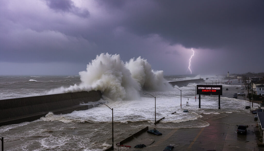
An avertissement d’onde de tempête—a storm surge warning—signals one of the most dangerous threats coastal communities face during severe weather. Unlike the dramatic winds of a cyclone or the visible deluge of rainfall, a storm surge arrives as a relentless wall of water that can inundate low-lying areas hours before the storm’s center reaches land.
These warnings indicate an abnormal rise in sea level generated by a storm, existing over and above predicted astronomical tides. While often associated with tropical hurricanes, such alerts apply to any powerful cyclonic system capable of pushing seawater toward shorelines, including winter storms and extratropical cyclones.
Understanding the mechanics behind these alerts, the authorities who issue them, and the specific actions required when warnings activate can mean the difference between safety and catastrophe. From the wide continental shelves of the St. Lawrence River to the Atlantic coasts of France, the threat spans global shorelines with locally distinct characteristics.
What is an Avertissement d’Onde de Tempête?
An abnormal rise in sea level driven by storm forces, exceeding normal astronomical tides.
Environment Canada, Météo-France, and NOAA/NWS.
Coastal flooding, erosion, infrastructure damage, and saltwater contamination.
Typically 12–36 hours during the storm’s peak impact.
- Storm surges can elevate water levels from 1 to over 10 meters above normal tides depending on regional geography.
- Low atmospheric pressure contributes approximately 5% to total surge height, with strong winds accounting for the remainder.
- Warnings typically provide 24 to 48 hours of preparation time before peak inundation.
- The phenomenon poses the deadliest threat in coastal storms, surpassing wind and rain fatalities historically.
- Surge impacts extend inland for kilometers through bays and estuaries, not just immediate beachfronts.
- Extratropical storms frequently generate significant surge events outside traditional hurricane seasons.
- Peak destruction occurs when surge coincides with high astronomical tide, compounding the water level.
| Characteristic | Details |
|---|---|
| Primary Mechanism | Wind-driven accumulation of ocean water |
| Pressure Contribution | ~5% of total surge height |
| Wind Contribution | ~95% of total surge height |
| Geographic Amplification | Wide continental shelves increase height; narrow shelves reduce it |
| Warning Lead Time | 24–48 hours typical |
| Duration of Event | 12–36 hours during storm peak |
| Threat Zone | Coastal areas within 10 km of shore |
| Regional Terminology | Avertissement d’onde de tempête (French); Storm Surge Warning (English) |
| Peak Risk Timing | Coinciding with high astronomical tide |
| Classification Thresholds | Minor (1–3 ft), Moderate (3–6 ft), Major (>6 ft) |
| Historical Significance | Leading cause of death in tropical cyclones |
| Global Occurrence | All oceanic coastlines exposed to cyclonic activity |
Storm Surge Warning Levels
Meteorological agencies categorize surge threats to communicate severity effectively. Minor surges ranging 1 to 3 feet above normal tide levels may cause localized flooding of vulnerable roads and low-lying property. Moderate levels between 3 and 6 feet threaten numerous coastal roads and ground-floor structures, often requiring evacuations in exposed areas.
Major surges exceeding 6 feet pose catastrophic risks, potentially devastating coastal communities with deep inundation, structural destruction, and long-term infrastructure damage. According to oceanographic research, these classifications align with the Saffir-Simpson scale for hurricanes, though extratropical systems can also trigger high-level warnings.
What Causes a Storm Surge?
A storm surge develops when strong winds from hurricanes, tropical storms, or extratropical cyclones pile seawater into a mound at the storm’s center, which advances onshore as flooding. This process involves complex interactions between atmospheric forces and ocean dynamics.
Key Factors Contributing to Storm Surges
Wind setup represents the dominant mechanism. Winds push water via the Ekman spiral, creating currents that increase levels downwind. This effect proves proportional to water depth and fetch—the distance over which wind travels unobstructed. Research on storm dynamics indicates that wind setup accounts for the vast majority of surge height.
Low atmospheric pressure raises sea level slightly by reducing the weight of the atmosphere pressing on the ocean surface. While this contributes only about 5% to total surge height, according to disaster response analysis, it remains a measurable factor in precise forecasting.
The Coriolis effect bends currents to the right in the Northern Hemisphere, amplifying surge perpendicular to shorelines. Additionally, a storm’s forward speed determines surge distribution: slower storms build broader inland surges, while faster systems concentrate peak impacts on open coasts.
While strong winds drive approximately 95% of a storm surge’s height, low atmospheric pressure plays a subtle but measurable role. Reduced atmospheric weight allows sea levels to rise roughly 5% higher than wind effects alone would suggest, a factor critical to precise predictive modeling.
Storm characteristics directly dictate surge magnitude. Higher wind speeds generate taller water mounds, with Category 4 and 5 storms producing the worst impacts. Storm size matters significantly—a doubled wind field diameter quadruples the affected area. The approach angle also proves crucial; storms moving perpendicular to coastlines create maximum surge potential, as climate risk assessments demonstrate.
Storm Surge vs. High Tide: Key Differences
Confusion persists between storm surges and astronomical high tides, yet the distinction carries life-saving implications. High tides represent the normal, predictable rise and fall of sea levels caused by lunar and solar gravitational forces. A storm surge represents a temporary, weather-driven anomaly that stacks atop these normal cycles.
When surge coincides with high tide, the combined water level—termed storm tide—creates the most destructive flooding scenarios. Conversely, if surge arrives during low tide, coastal areas may experience minimal flooding despite the storm’s intensity.
Storm Surge vs. Tsunami
The difference between a storm surge and a tsunami proves fundamental to appropriate response strategies. According to meteorological explanations, tsunamis constitute sudden, wave-like displacements of water typically generated by seismic activity or underwater landslides. These events propagate across oceans at high speeds as discrete waves.
Storm surges, by contrast, present as sustained rises in water level rather than breaking waves. Wind drives them, not seismic forces, and they do not propagate across ocean basins as tsunamis do. While tsunamis bring rapid, pulse-like flooding, storm surges persist for hours or days, allowing preparation time but prolonging exposure to damaging conditions.
What to Do During a Storm Surge Warning
Receiving an avertissement d’onde de tempête requires immediate, specific actions distinct from general storm preparations. Unlike wind or lightning threats, surge dangers necessitate geographic evacuation rather than sheltering in place.
Preparation Steps
Monitor official warnings from local authorities such as Environment Canada for Quebec regions or Météo-France for Atlantic coasts. Elevate belongings to upper floors if evacuation proves impossible, though leaving remains the safest option. Stock essential supplies including potable water, non-perishable food, and medications sufficient for 72 hours of potential isolation.
Evacuation Guidelines
Follow evacuation orders immediately when issued for low-lying or coastal areas. Identify primary and secondary evacuation routes before storms approach, as road flooding may block standard paths. Move to designated shelters or higher ground inland, not simply to adjacent buildings or elevated floors within flood-prone zones.
Authorities issue evacuation orders based on surge arrival times, not storm landfall. Waiting until rain begins or winds intensify often leaves insufficient time to reach safe zones, as surge waters may already have blocked escape routes.
Residents along wide continental shelves—such as those bordering the Gulf of St. Lawrence—face heightened surge risk compared to areas with steep offshore drop-offs. Scientific analysis confirms that shelf bathymetry significantly amplifies surge height.
During the event, avoid beaches, coastal roads, and boardwalks entirely. Surge waters often hide sharp debris, electrical hazards, and powerful currents capable of sweeping away vehicles and structures. Even experienced swimmers cannot fight the sustained flow of surge flooding.
Who Issues Storm Surge Warnings and Where?
Warning systems vary by region but share common goals of accuracy and rapid dissemination. Understanding the specific terminology and alert mechanisms in your area proves essential for timely response.
Issuing Authorities by Region
In Canada, Environment Canada issues avertissements d’onde de tempête for Quebec’s St. Lawrence and Gulf coasts, as well as Atlantic provinces. These alerts target the unique bathymetry of Canadian waters where wide continental shelves amplify surge potential.
Météo-France monitors Atlantic coastlines, issuing warnings for regions vulnerable to extratropical surges sweeping in from the Bay of Biscay and English Channel. NOAA’s National Weather Service provides equivalent warnings for United States coastlines, utilizing sophisticated surge modeling to predict inundation zones.
According to official meteorological guidelines, these agencies distinguish between advisories—indicating possible minor flooding—and warnings, which signal imminent, life-threatening surge conditions requiring evacuation.
The Timeline of a Storm Surge Event
- Storm Approach: Meteorological agencies issue watches 48 hours before potential impact, identifying regions where surge conditions may develop.
- Warning Activation: As storm trajectories confirm threat paths, official warnings activate 24 to 48 hours before surge arrival, triggering evacuations.
- Peak Inundation: Water levels reach maximum height as the storm’s center crosses the coastline, potentially persisting for several hours during slow-moving systems.
- Recession and Recovery: Surge waters gradually retreat, though authorities maintain advisories for 12 to 24 hours afterward due to debris, structural instability, and contaminated floodwaters.
Certainty and Uncertainty in Surge Forecasting
| Established Understanding | Remaining Uncertainties |
|---|---|
| Driven primarily by wind dynamics and storm characteristics | Exact height predictions carry ±20–30% margins of error |
| Predictable within 24–48 hour windows using current models | Last-minute shifts in storm intensity alter projections |
| Amplified by wide continental shelves and funnel-shaped coastlines | Local topography creates unpredictable micro-variations in flooding |
| Occurs in both tropical and extratropical cyclone systems | Precise timing of surge peak relative to high tide remains variable |
Historical Context and Regional Vulnerability
The deadliest storm surge in recorded history struck Bangladesh in 1970, killing hundreds of thousands and demonstrating the catastrophic potential when high populations occupy low-lying deltas. In North America, Hurricane Katrina’s surge devastated New Orleans in 2005, while Canada’s Hurricane Igor in 2010 inflicted severe damage on Newfoundland’s coast.
Express Entry Draw History – Complete CRS Scores and Results 2015-2024 provides insight into historical data patterns, though meteorological history offers more direct lessons for coastal preparedness. Quebec’s St. Lawrence River region faces particular vulnerability due to its wide, shallow continental shelf that amplifies surge heights from Atlantic storms tracking northward.
Climate change introduces additional variables, with rising sea levels effectively increasing the baseline upon which storm surges build. This amplification means identical storms today generate higher inundation than historical equivalents, necessitating updated evacuation mapping and infrastructure planning.
Expert Perspectives on Coastal Threats
Storm surges are the deadliest part of coastal storms.
— Environment Canada
The abnormal rise in water level generated by a storm represents a combination of wind-driven water and slight atmospheric pressure effects, creating sustained flooding unlike any other weather phenomenon.
— Storm Surge Research Documentation
Essential Points for Coastal Residents
An avertissement d’onde de tempête demands immediate evacuation from low-lying areas, not merely preparation for wind and rain. These warnings indicate a sustained rise in sea level driven by storm winds, distinct from tsunamis or normal tides, capable of penetrating kilometers inland through bays and estuaries. While forecasters can predict surge occurrence with 24 to 48 hours of lead time, exact heights remain uncertain within 20 to 30% margins, necessitating conservative safety margins when planning evacuations. Valley First Credit Union – Branches, Services, Membership Guide offers resources for community members managing property and financial preparations.
Frequently Asked Questions
Can a storm surge happen without a hurricane?
Yes. Extratropical cyclones, winter storms, and powerful nor’easters frequently generate significant surge conditions along exposed coastlines, regardless of tropical classification.
What are the levels of storm surge warnings?
Authorities classify surges as minor (1–3 feet), moderate (3–6 feet), or major (exceeding 6 feet above normal tide levels), with classifications guiding evacuation decisions.
How is a storm surge different from a tidal surge?
While often used interchangeably, tidal surge specifically emphasizes interaction with astronomical tides, whereas storm surge refers strictly to meteorological wind and pressure forcing.
Where are storm surge warnings most common?
High-risk regions include the U.S. Gulf Coast, Atlantic Canada, the French Atlantic coast, Bangladesh, and any area with wide continental shelves exposed to cyclonic activity.
How long does a storm surge typically last?
The elevated water level generally persists for 12 to 36 hours, peaking when the storm center crosses the coastline and gradually receding thereafter.
What makes storm surge predictions uncertain?
Exact height forecasts carry margins of error between 20% and 30% due to unpredictable last-minute shifts in storm intensity and local topographical variations.
More related posts
 Al Nassr vs Al Hilal: Head-to-Head, Wealth & Rivalry
 God Is a Bullet: True Story, Plot, Cast & Reviews Explained
 Red Lobster Seafood Boils: Menu, Prices & Health Guide
 Sunrise on the Reaping Cast: Haymitch, Effie & Snow Revealed
 The Wizard of Oz – Plot, Cast, Songs, History and Legacy
 Cristiano Ronaldo Jr: Age, Height, Career & Facts
 Jalen Brunson Biography: Wife, Height, Contract and Stats
 Lola Tung: Age, Ethnicity, Movies, and FAQs
